
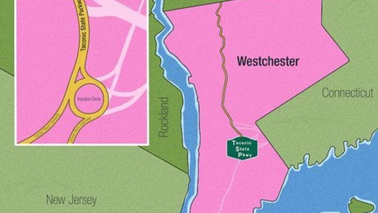
Travel in Westchester County.

In Westchester County, this route starts at the northern terminus of the Bronx River Parkway at the Kensico Circle just to the south of Kensico Dam in New Castle, NY. The Taconic State Parkway travels from its southern terminus at the former Hawthorne Circle (northwest of Bronxville) then swivels around until it goes through Sprain Ridge Park up through various towns, past Interstate 287's exit up to the Hawthorne's exits on a northeast course. It continues northeast from a point south of the Hardscrabble Wilderness Area up to FDR State Park, then turns and heads northwest again until it reaches the county border near Jefferson Valley. The Taconic - as it's more commonly called - begins as an extension of the Bronx River Parkway (as a freeway) until it reaches the connection point to the Sprain Brook Parkway, just north of the Sprain's Westchester County Hospital and connections to the grave site of George Herman "Babe" Ruth and more inside the Gate of Heaven and Mount Pleasant Cemeteries.. It has exits for the Bronx River Parkway (for southbound travelers) as a southern terminus in North Castle (unnumbered), and seven unknown numbered (new numbered) exits for Valhalla and Mount Pleasant (W1, W2, W3, W4, W5, W6, W7), all within the first 2.4 miles (3.9 km) of highway. You'll have exits for Broadway to I-287 (W1), Cleveland Street and Valhalla Station (W2), Valhalla Place (W3), Legion Drive (W4), Lakeview Ave and Kensico Cemetery-Sharon Gardens (W5), Commerce Street (W6) and Stevens Ave-Mount Pleasant (Train) Station (W7). It passes two Metro-North Railroad Stations at Mount Pleasant and Valhalla until it reaches the northern terminus of the Sprain Brook Parkway (southbound) and NY-141/NY-9A (northbound exit) at mile marker 2.85 miles (4.59 km) at new exit number 2. However, most navigation apps will direct you onto the Sprain Brook Parkway, as it avoids most of the issues this highway has in this area - and connects you quicker and easier, seeming like the Sprain is an extension of this highway. It continues as quick exits past the Saw Mill River Parkway (exit 3) in Hawthorne, and exits 4 and 5 in Mount Pleasant, Briarcliff Manor (6), Millwood (8), New Castle (9), and Yorktown-Ossining (11). At exit 3 with the stack-interchange with the Saw Mill River Parkway, recognize that this was the site of the famous Hawthorne Circle, where there was a giant traffic circle as a roundabout between two main parmways/highways. But this traffic circle was replaced in the 1970s and 80s. As you encounter this exit, you'll notice the looming Turkey Mountain in your distance. It passes over the AMVETS Memorial Bridge - an untolled bridge consisting of .2 miles (0.32 km) bridge crossing over the Croton Reservoir. It continues past Yorktown (exits 13, 14, 15, 16), past Crompond (17A, 17B), and past Shrub Oak. (19, 20). In this stretch, you'll pass exits for the Bear Mountain State Parkway to US-202, US-6 (exit 20), and the FDR State Park (16) - among the most popular exits. The Bear Mountain Parkway is a legacy highway that was planned as the original route and purpose of the Taconic State Parkway, but drops into a valley carved by the Hudson River Tributary. Towards the northernmost end of the Westchester County parcel sits Donald J. Trump State Park. You see, Donald Trump - a developer at the time - donated the land to the State of New York, and although most of the land sits undeveloped, there have been several attempts to rename the park. Some tennis courts and a few other buildings remain. Its park standing sets it as not being open to the public, though it has people walking around in it from time to time. All of the smaller crossroad exits were replaced or eliminated within Westchester County, leaving only at-grade intersections open to exiting and entering vehicles. There are no cross-street intersections in this county's Parkway span.
Travel in Putnam County
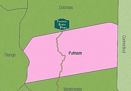
In Putnam County, this highway travels in a more northeast direction from the time it enters from Westchester County until it reaches just north of the Town of Tompkins Corners, where it swivels back around and heads into an S-curve just south of the Kings Chamber, then heads north again after 30 seconds travel, then heads north once again on another curve- as it makes its way through Clarence Fahnestock State Park, and moves through the rest of the Hudson Highlands with no visible developments on the highway. Expect exits for Putnam Valley at Bryant Park Road and Peekskill Hollow Road (exits 23, 25), Fahnestock State Park (28), and Kent (31). Between exits 25 and 28, you'll spot a sign saying that you've received the apex of the highway - the top elevation on the route - at 1,200 feet above sea level. There are only two intersecting roadways in Kent for Hortontown Hill Rd and Knapp Rd, though Knapp Rd only has connections to northbound travelers only.
Travel in Dutchess County.
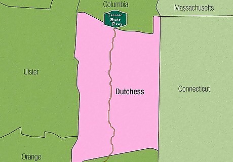
In Dutchess County, the Taconic State Parkway travels a U-shaped path in the southern portion, until it reaches a point near Hillside Lake. This point is where it travels pretty much in a straight path until it exits into the next county. It begins in the Town of East Fishkill, where you'll find exits for Miller Hill Rd (where the site of the Appalachian Trail crossing exists, exit 35), Interstate 84 (37), NY-52 (exit 38), Beekman Rd to Hopewell Junction (41), and NY-82 to Hopewell Junction and Arthursburg (43). At the I-84 interchange, you'll arrive at the only full cloverleaf exit along the route. However, past that, wider medians and gentler turns take the highway through lower hills where there are no shoulders. It continues through LaGrange - and after its first exit for CR-42/Arthursburg Rd (45) - has a Taste NY Store which was the former Todd Hill Rest Area. It then encounters exits for NY-55 to Pawling and Poughkeepsie, James Baird State Park (which is a left-hand exit northbound). As you enter Dutchess County, you'll notice the hills just north of you and the valley to your west between two mountains, as well as some scenic vistas to the west. Continue through Pleasant Valley to the US-44 exit towards Poughkeepsie and Millbrook/Pleasant Valley at exit 54. Continue up to Clinton for the Salt Point Turnpike (NY-115) at exit 58 (NY-115). Continue to Stanford for the Bulls Head Rd exit towards Rhinebeck and Stanfordville (exit 64). High-tail up to Milan's NY-199 exit (67) towards Pine Plains and Red Hook, and a slight connection to Rhinebeck off of the main route. Intersections in this county include Hosner Mountain Rd (where there's a blinking yellow light on the Taconic State Parkway, just before a rarely-used railroad track, but there is no connection to the southbound lanes of the Taconic State Parkway), Carpenter Rd, Todd Hill Rd, Mountain Rd, McDonnell Rd (for southbound only), Rossway Rd/Drake Rd, Tyrrel Rd, Forest Ridge Ln, Hibernia Rd, Hollow Rd, Willow Ln (southbound only), Nine Partners Rd, Willow Brook Rd, Cold Spring Rd, North Rd, Wilbur Flats Rd and Ferris Ln. About .25 miles (0.40 km) north of Rossway Rd off a dead end road, you'll find access to the Taconic-Hereford Multiple Use Area.
Travel in Columbia County.
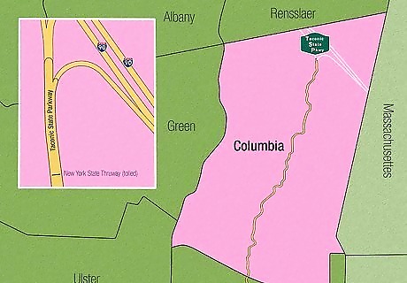
Columbia County is the last county on the route. It travels mostly northeast, but on a squiggly path that avoids heading through other towns. The first exit - for Gallatin is literally on the border between the two counties, according to the former exit numbering - at Jackson Corners Rd (CR-2) towards Elizaville/Ancram. By the time you cross over from Dutchess County, you'll have passed over the Roeliff Jansen Kill Multiple Use Area, however, you'll see some of the Catskill Escarpment to the west. Each town going north has its own exit. Taghkanic is next - NY-82 (80), though there are also at-grade intersections prior to serving Lake Taghkanic State Park at CR-15 and the unnumbered Lake Taghkanic State Park - both prior to the numbered exit. You will pass the beach from the highway and you'll notice a park access road leaving the highway to the east as the highway enters the Town of Taghkanic. Make your way to Claverack's NY-23 towards either Claverack or Hudson (exit 88). This route also gives you access to the Athens Hudson Ferry and Rip Van Winkle Bridge (a New York State Bridge Authority bridge). Head towards Ghent's exit for NY-217 towards Harlemville or Philmont-Hudson. At one point here, you'll also spot a parking area attached for a Diner overlooking the valley. Stop by Austerlitz-Chatham-Valatie's exit 99 at NY-203. Worry about Chatham's exit 102 (at 101.88 miles (163.96 km) northbound. There's also a separate southbound exit at mile marker 104.00 miles (167.37 km) but mileage and exit (same exit numbers) don't correspond. Watch for the Northern terminus within Chatham for I-90 and the Berkshire Connector to the New York State Thruway (tolled) at exit B2 heading towards Boston (east) or Albany (west), though with the Berkshire Connector's route (heading west). You can also connect to the tolled route of the New York State Thruway taking you south to New York City, if necessary. Right in/right out intersections include Ten Neighbors Rd, CR-10, Post Hill Rd, Snydertown Rd, Manor Rock Rd, Bauer Rd, Palmer Rd, Harlemville Rd, and Rigor Hill Rd (including the food mart and Citgo gas station).


Comments
0 comment