views
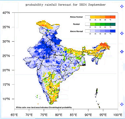
After heavy rain in August, the India Meteorological Department (IMD) has forecast above-normal rain in September as well. According to the forecast, the overall rainfall is likely to be more than 109% of the long-period average (LPA) for the month which is 168mm.
“We are expecting low-pressure systems to form almost every week, which would bring continuous rain. There can be extremely heavy rain episodes in the foothills of the Himalayas, especially Uttarakhand, Himachal Pradesh, J&K, Punjab, as well as Rajasthan, leading to landslides/floods. So we should be cautious,” said Director General of Meteorology (DGM) M Mohapatra on Saturday.
At least two such systems – termed as cyclonic disturbances – are likely to form in the coming week – one over Arabian Sea and the other over Bay of Bengal. Then, two more such systems are likely to form during the second and third week- all of which are expected to move over Odisha towards west Uttar Pradesh.

According to MeT, most of these systems forming in the Bay of Bengal this month are likely to travel north-west up to Rajasthan and bring rain over North-west India. Low-pressure systems are weather systems responsible for most of the rain during the monsoon. To lend more momentum, the monsoon trough may also shift to foothills of Himalayas during the period.
On the other hand, parts of south-peninsular India like Rayalseema, southern Karnataka, north Bihar and north-east Uttar Pradesh and most parts of north-east India could see less rain. Overall, the southwest monsoon is now 7% above the long-period average (LPA).
The temperatures are likely to remain above-normal during the day and night. The extended range forecast for the next two weeks has also predicted extremely heavy rains over Gujarat and Andhra Pradesh this week, and heavy rain for the next two weeks over Central India, North-west India, and northern parts.
After a sub-par performance in June, the southwest monsoon gained momentum in July and brought above-normal rain over the past two months. While July ended with 9% above-normal rain, higher than what IMD predicted, the August rainfall, too, exceeded the forecast with an excess of 15%. This was much higher than the IMD’s forecast of ‘normal rain’ – less than 106% of the long-period average (LPA).
The Bay of Bengal arm of the monsoon remained active throughout the month, churning out multiple weather systems. There were six such systems, one of which intensified into a rare cyclone over Arabian Sea in the monsoon.


Comments
0 comment