views
Green Top has embedded itself like a thorn at the heart of the disengagement process on the Line of Actual Control in Ladakh and is threatening to poison the wider India-China talks aimed at drawing down troops before the winter, government sources have told News18.
People’s Liberation Army negotiators declined to commit to remove troops from the tactically-significant location near Pangong Lake during the marathon talks held at the Chinese base of Moldo on Sunday.
A bush-covered plateau perched at over 5,000 metres on a ridge stretching out from Pangong’s north shore, Green Top is one of a handful of locations on which PLA and Indian Army negotiators remain deadlocked despite five rounds of high-level talks.
New Delhi hopes parallel diplomatic efforts, involving both the Ministry of External Affairs and National Security Advisor Ajit Doval, could help resolve the disputes over Green Top, Patrol Point 17A near Gogra, and Patrol Point 13 near the Depsang Plains.
Last week, Chinese foreign ministry spokesperson Wang Wenbin had said “most of the bases deployed on the front have completed the evacuation process and the ground conditions are recovering”. He acknowledged the existence of “remaining outstanding issues”.
But, officials say scepticism is mounting in the government about the PLA’s willingness to withdraw from all territories it occupied in April. “The talks have achieved their immediate intent, which was to avoid violence,” a senior intelligence official said. “The fact that China is still occupying territory it grabbed in April may not be a deal-breaker, but it certainly undermines trust”.
PLA commanders, government sources say, are seeking to hold on to Green Top because it offers a clear line of observation over Dhan Singh Post, the main logistics hub for Indian troop movements around Pangong Lake. In the negotiations, the PLA has claimed its position on Green Top is legitimised by the build-up of Indian roads and communications infrastructure in the area—in turn, a response to years of construction work by China.
“Their argument is that India has also violated the status-quo in the Pangong area,” an officer familiar with the talks said. “This claim has no basis, because all the works India has undertaken are clearly on our own side of the LAC”.
From Green Top, connected by road to PLA bases near Sirijap, the PLA is able to observe Indian Army patrols headed out eastwards towards the LAC, thus enabling rapid interdiction.
Eight ‘Fingers’, or ridges, radiating from the north shore of Pangong Lake, are contested by China and India. India claims the LAC runs near Finger 8, west of China’s forward bases at Sirijap, and has long despatched patrols to the area. This summer, though, the PLA dug in at Finger 4—where Green Top is located—obstructing Indian patrols from moving westwards.
Force levels have thinned significantly all the way to Finger 5, government sources say, but the PLA has continued to maintain its presence at Green Top.
India had maintained a permanent position at Finger 7 until the 1999 Kargil war, when it was evacuated to provide troops for the conflict with Pakistan. The PLA then built roads into the sector, ensuring the post could not be re-established.
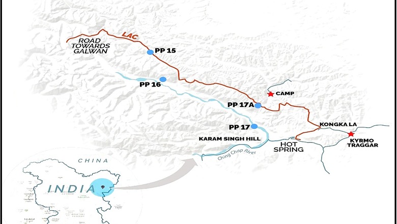
Located in the shadow of Karam Singh Hill—named for the Central Reserve Police Force officer who led the unit involved in a murderous 1959 ambush which claimed the lives of ten Indian personnel—Patrol Point 17A, near Gogra, has emerged as second key point of contestation.
Even though troops are no longer engaged in eyeball-to-eyeball confrontation, the PLA has continued to maintain a small presence near Point 17A, instead of pulling back.
China long ago pushed into parts of the LAC around Gogra, and the nearby Hot Springs area—notably, building a road that cuts across Indian-claimed territory north of the 6,300 metre Changlung La pass, and then traverses Point 15 to enter the Galwan Valley.
Patrol Points, numbered north to south with Point 1 located at the Karakoram Pass, make the physical limits to which Indian soldiers assert their presence on the LAC.
To the north of the Galwan Valley—the site of the murderous PLA ambush on June 15 clash, in which 20 Indian soldiers were killed—China has continued to build road-works at Point 13. The Indian Army fears the new works could join up with existing roads built on the Indian side of the LAC near Burtsé, and eventually cut off Indian troops seeking to patrol the Depsang Plains.
No official maps recording the two sides’ claims have been made public, but the scholar P Stobdan has recorded that China asserts rights to 972 square kilometres of territory on the Indian side of the LAC in the Depsang Plains, 176 sq. km. along the Samar Lungpa river, 38 sq. km. at Hot Spring, 13 sq. kilometres in Changlung, 5 sq. km. in Kungkala-Phobrang, 129 sq. km in Sirijap; 24 sq. km in Spanggur, and 25 sq. km. in Dhumtsele”. In addition, there are Chinese claims of 83 sq. km. in the Pangong area, and 80 sq. km. in Chumar.
“The territories China is trying to hold on to all lie in the disputed zones,” a senior government official said. “In the event they do not vacate them, there will be good reason for suspicion about their course of action, going forward”.
Future talks, the official said, will focus on re-instituting patrols, suspended by both armies after the violent clash in the Galwan Valley, and creating a system to avoid face-offs between troops. New Delhi has been seeking wider discussions to firm up the LAC, but several proposals to engage in border-demaraction have been rejected by China.


Comments
0 comment